|
|
File
Roman road and late antiquity religious buildings at the Cathedral – Concordia Sagittaria
|
| Piazza Cardinal Costantini 1 – 30023 Concordia Sagittaria (VE)
|
  |
|
Summary

The archaeological area at the Cathedral of Concordia mainly displays the remains of the early Christian compound that was built from IV century A.D. onwards along the main east-west city road, the so-called “decumanus maximus”, in its extra-urban area. It also partially displays few aspects of the previous Roman phase of the settlement, particularly part of a road and of some commercial buildings.
History of research
The excavations were carried out between 1950 and 1970 by the University of Padova. They were started again in 1983 by the General Direction for Archaeological Heritage in the Veneto region and they continued until 1999.
Urban and geographical context
Concordia Sagittaria is located in the north-eastern Veneto plain, in a territory surrounded by the Tagliamento river on the east and the Livenza river on the west. The main river of the city is the Lemene, which flows from the springs strip, passes through the centre of Concordia and finally flows into Valle Zignago, the northernmost extreme of the lagoon in Caorle. The archaeological area is located at the core of the modern city of Concordia and used to be along the centre-eastern margins of the Roman settlement, just out of the city walls.
Chronology
I B.C. (end) – VI A.D. |

 The archaeological area at the Cathedral of Concordia mainly displays the remains of the monumental early Christian group of buildings and, for some parts, of the Roman phase of this settlement. The archaeological area at the Cathedral of Concordia mainly displays the remains of the monumental early Christian group of buildings and, for some parts, of the Roman phase of this settlement.
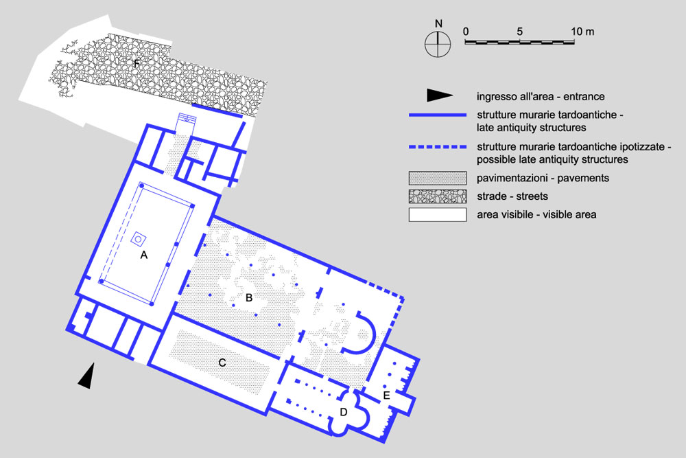
The visit itinerary starts from the “quadriportico”, a four-sided porch (A), continues through the “Basilica Apostolorum” (B) up to the paved courtyard on its southern side (C). It finally reaches the “Trychora Martyrum” (D) and the necropolis with the tomb of Faustiniana (E).
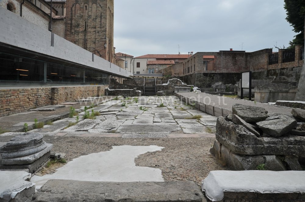
The Roman phase is documented by part of a paved road (F), which is located in the northern part of the archaeological area, and by some pieces of pavements in terracotta tiles which are visible underneath the presbytery of the early Christian Basilica. This pavement pertains to commercial buildings that have been dated to I – II century A.D. The road was still used in late antiquity and joined the “via Annia”. Truck traces are still visible today.
The late antiquity is documented by all the other remains in the archaeological area. The most ancient building is the “Trychora Martyrum” (D), which had three apses and which was built in mid IV century A.D. to contain the relics of Christian martyrs. At the end of the century the “Trychora” was transformed in a small “Basilica” by adding a building with two rows of columns and three naves on its front. Behind the “Trychora” there are the funerary enclosures (E), each with niches and front porch. In V century A.D. one of these enclosures was transformed in the private funerary chapel of Faustiniana, a lady of senatorial rank.
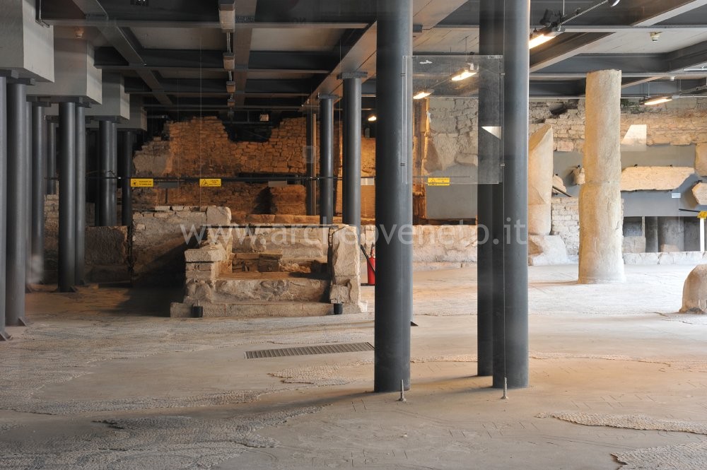
The Basilica Apostolorum (B) is the most important and biggest (m 40 x 20) building in the area and it was built at the end of IV century A.D. It is a church divided into three naves by Greek marble columns and paved with mosaics representing Christian images and symbols. The pavement of the presbytery was originally at the same altitude as that of the naves but it was raised in V century A.D. Under the presbytery it is still possible to see the terracotta pavements of previous buildings. A big four-sided porch (m 27 x 18,5, A) was built in front of the Basilica at the beginning of the V century. The porch was partially paved in mosaics and was accessible via the Roman road. Along the two short sides it is possible to notice some rooms which have been interpreted as episcopate (south) and as guesthouses for pilgrims and monks (north). Beside the Cathedral there is a paved courtyard (C), which was originally surrounded by a porch and through which it is possible to access a funerary area with various sarcophaguses. The religious compound was destroyed in the VI century A.D. by a fire and it was buried under thick alluvial layers between the end of the VI and the VIII century A.D.
|

Admission: Negli orari di apertura
Visitability: Interno
Ticket: No
 School access School access
 Disabled access Disabled access
Lift to access the site
Opening Days
| Tipology |
When |
Specs |
| Mon-Sun |
8.30 – 19.30 |
|
Closed: Christmas, New Year’s, I May
Recommended tour time (minutes): 80
 Toilet Toilet
 Guide a stampa Guide a stampa
 Information boards Information boards
 Multilingual ads: Inglese Multilingual ads: Inglese
Panels
 Guided Tours Guided Tours
For any information about guided tours please call tel. 0421 275677.
 Educational activities Educational activities
Teaching activities by the association "Studio D Friuli" (Francesca Benvegnù, tel. 3463257139; e-mail: studiodfriuli@alice.it).
 Library and documentation centre Library and documentation centre
| Scarpa Bonazza B. 1978, Iulia Concordia dall’età romana all’età moderna, Treviso, pp. 141-207. |
| Mangani E., Rebecchi F., Strazzulla M.J. 1981, Emilia, Venezie (Guide Archeologiche Laterza), Bari, pp. 201-206. |
| Croce Da Villa P. 1987, Concordia, in Il Veneto nell’età romana, II, a cura di Cavalieri Manasse G., Verona, pp. 405-407. |
| Croce Da Villa P. 2001, Il complesso paleocristiano di Piazza Cardinal Costantini, in Concordia Sagittaria. Tremila anni di storia, a cura di Croce Da Villa P., Di Filippo Balestrazzi E., Padova, pp. 253-267. |
| Il Museo Nazionale Concordiese di Portogruaro e le aree archeologiche di Concordia Sagittaria 2001, a cura di Croce Da Villa P. , Concordia Sagittaria (VE), pp. 71-78. |
| Il quadriportico della basilica paleocristiana di Concordia Sagittaria 2002, in Quaderni di Archeologia del Veneto, XVIII, a cura di Croce Da Villa P. , pp. 100-115. |
| I luoghi della cultura 2006, Roma, pp. 374-375. |
| Iulia Concordia, una colonia romana a NordEst 2006, in Archeologia Viva, 123, a cura di Pettenò E.. |
| Bonetto J. 2009, Veneto (Archeologia delle Regioni d’Italia), Roma, pp. 496-497. |
|


 School access
 Disabled access
 Toilet
 Guide a stampa
 Information boards
 Multilingual ads: Inglese
 Guided Tours
 Educational activities
 Library and documentation centre


